4.1 INTRODUCTION
The Accident Analysis System is developed using three software.
- .Net Framework
- MapXtreme
- RWNetServer
Their salient features are explained below
Visual Studio .NET allows to create applications that leverages the power of the World Wide Web. This includes everything from a traditional Web site that serves HTML pages, to fully featured business applications that run on an intranet or the Internet, to sophisticated business-to-business applications providing Web-based components that can exchange data using XML.
This topic provides an overview of the types of Web applications create in Visual Studio, how they relate to one another and to other Visual Studio technologies.
4.2.1 Visual
Studio ASP.NET Web Applications
A Visual Studio Web application is built around ASP.NET. ASP.NET is a platform - including design-time objects and controls and a run-time execution context for developing and running applications on a Web server.ASP.NET in turn is part of the .NET Framework, so that it provides access to all of the features of that framework. ASP.NET Web applications can create using any .NET programming language (Visual Basic, C#, Managed Extensions for C++, and many others) and .NET debugging facilities. Data can be access using ADO.NET. Similarly, operating system services also access using .NET Framework classes.
ASP.NET Web applications run on a Web server configured with Microsoft Internet Information Services (IIS). However, need not directly work with IIS. You can program IIS facilities using ASP.NET classes, and Visual Studio handles file management tasks such as creating IIS applications is needed and providing ways to deploy Web applications to IIS.
The advantage of using Visual Studio is that it provides tools that make application development much faster, easier, and more reliable. These tools include:
- Visual designers for Web pages with drag-and-drop controls and code (HTML) views with syntax checking.
- Code-aware editors that include statement completion, syntax checking, and other IntelliSense features.
- Integrated compilation and debugging.
- Project management facilities for creating and managing application files, including deployment to local or remote servers.
4.2.2 Elements
of ASP.NET Web Applications
Creating ASP.NET Web applications involves working with many of the same elements in any desktop or client-server application.
- Project management features when creating an ASP.NET Web application, need to keep track of the files, which ones need to be compiled, and which need to be deployed.
- User interface application typically presents information to users; in an ASP.NET Web application, the user interface is presented in Web Forms pages, which send output to a browser. Optionally, you can create output tailored for mobile devices or other Web appliances.
- Components Many applications include reusable elements containing code to perform specific tasks. In Web applications, these components are created as XML Web services, which makes them callable across the Web from a Web application, another XML Web service, or a Windows Form.
- Data Most applications require some form of data access. In ASP.NET Web applications, ADO.NET, the data services which is a part of the .NET Framework.
- Security, performance, and other infrastructure features As in any application, security to prevent unauthorized use, test and debug the application, tune its performance, and perform other tasks not directly related to the application's primary function.
4.3 MAPXTREME
2005
MapXtreme 2005 is MapInfo Corporation’s premier Windows software development toolkit that allows .NET-experienced developers to create powerful location-enhanced desktop and client/server applications. MapXtreme customised application can be developed in.NET programming language, share and reuse code between desktop and web deployments, access data from a wide variety of sources using standard protocols, and more. This is all possible through MapXtreme 2005’s object model, an API of 100 percent managed code that was developed on Microsoft’s .NET Framework. The Framework’s Common Language Runtime (CLR) provides the foundation that makes simplified development a reality. The following components and features are included in MapXtreme 2005:
• Product framework: The MapXtreme 2005 Object Model is compatible with the .NET Framework 1.1. By basing it on Microsoft’s .NET framework, MapXtreme takes advantage of many of its features, such as ADO.NET.
• Development Environment Tools: A variety of templates, controls, sample code and tools help you develop Windows Forms and ASP.NET applications within Visual Studio .NET. can extend some of these components to provide more advanced functionality available through the object model. Two data management utilities are included for managing tables that will use in application ( Geo-dictionary Manager) and manage workspaces for ease of use and portability (Workspace Manager).
• Full Mapping and Analytical capabilities: Map creation and display, data access, thematic mapping, raster and grid handling, object processing and presentation, and more.
•
Scalable Infrastructure: Session
object pooling and caching capabilities offer big performance gains for web
applications. Maintain session and user information by saving information to
MapXtreme’s XML-based workspace format. Core
MapXtreme 2005 Classes
• Runtime Deployment: MapXtreme 2005 uses Windows Installer technology (merge modules) that developers can use to install or redistribute runtime components used in deployed applications.
• Extensive Documentation: Product documentation is at your fingertips as integrated components in the Visual Studio .NET development environment. The MapXtreme Resources page keeps you connected to all product resources. It’s available from the Start menu.
4.3.1 ASP.NET
Web Applications
Visual Basic.NET. To create a Visual C# ASP.NET map application substitute Visual C# for Visual Basic in the following steps.
1. From the Visual Studio .NET FILE menu, point to NEW then click PROJECTS. The New Project dialog box displays.
2. In the Project Types frame of the New Project dialog box, under the MAPXTREME PROJECTS folder, click VB PROJECTS.
3. In the Templates frame of the New Project dialog box select ASP.NET MAP APPLICATION.
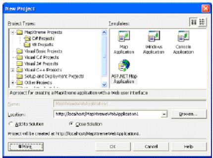
Fig 4.1 Window to
start MapXtreme Web application
4. Choose an appropriate location and click OK. MapXtreme 2005 creates the application and WebForm1.aspx displays.
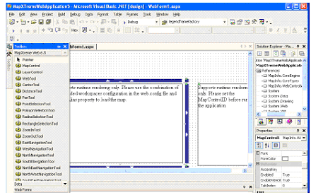
Fig 4.2.MapXtreme web application in .Net
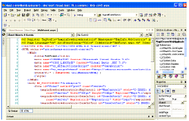
Fig4.3. Net HTML coding
5. Click HTML, at the bottom of WebForm1.aspx to view the HTML for the application.
6. On the DEBUG menu, click START to run the application.
7. Use the controls in the toolbar to manipulate the map as you would with any other MapInfo mapping application.
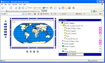
Fig 4.4.MapXtreme web application user
interface in Internet explorer (web page)
4.4
RWNetServer
RW NetServer is the server version of RW Net development framework. The absolute majority of features from the RW Net Standard development framework is readily available in the server. A few of the features from RW Net Pro will also be available in RW NetServer Pro (details not available yet). The server is designed to operate with a high uptime, high performance and with a high level of scalability. This design is possible because of the true application server structure on which the RW Net framework capabilities are provided. RW NetServer consists of 3 main parts:
MakeNetwork
An import application (runs on Windows only). This is for setting up the street network for use in the server.
Server
The server has built-in "application server technology" (known as kbmMW) and can run as a console application on Linux (x86) and most flavours of 32 bit Windows (NT 4, Win 2000, XP, Win 2003). It can also be installed as an NT service on Windows or a daemon on Linux.
A client is required to talk to the server. Cross platform communication is fully supported. This means that clients and servers can run on different platforms without problems. RW NetServer is available in two versions, Standard and Pro, which are the same except for two differences: Standard allows 500,000 links in the road network, while Pro allows 16,000,000 links. This limit applies to both RWNetServer and MakeNetwork application.
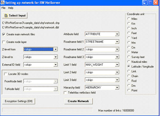
Fig4.5 Setting the network in RWNetServer
software
RW NetServer can, on the Windows platform, be run as a
normal application, or as an NT service. On Linux, it can be started as a
daemon or console application.
Start the server simply by executing the
rwnetserver3.exe. After starting the server, it must be instructed to listen
for clients. This is done by clicking the Listen button. Stop the server by clicking on the 'x' to
close the application. Alternatively one can click the 'Don't listen' button to
let the server continue to run, but not accept any more requests from clients
on any of the defined transports.
The GUI includes a log part which contains all the
messages that is logged to the standard log file rwnetserver.log residing in
the same directory as the executable file itself. Via the interface, one can
enable extra debug information which show in more detail what functions clients
are calling. Additionally one can enable exception log. One should usually only
use these settings for debug purposes, and not when the server is to operate in
production mode.
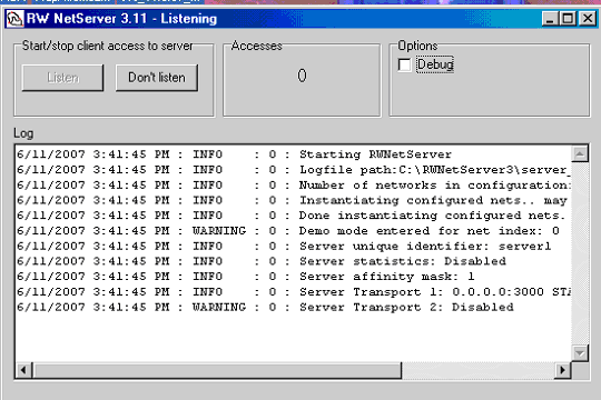
Fig 4.6 Operating as a normal application (Windows)
4.5 DESCRIPTION
OF THE DEVELOPMENT SYSTEM
User Interface is a webpage in which client can interact with server. This will provide analysis tools for the client and display the result required for the client from severs. The user interface created in .Net framework using C# programming language. MapXtreme is GIS web server, which has capability to serve the map through Internet. In addition, allow the user to do analysis through Internet.
This System has three main model for accident data collection, storing and analysis. The models are Data Entry form and Analysis.
4.5.1 DATA
ENTRY
User interface is developed in .Net platform using C# programming language. Fig4 .7 shows the starting user interface of the developed system. This interface will direct the user according to the selected options displayed in window. Now assuming the user has selected the Data Entry option, this page will be directed to data entry form which is shown in fig 4.7.
Data entry form is designed base on Micro Computer Accident Analysis Package and IRC format and the data will be stored in MS access database. This data base can be changed to other database server like SQL and Oracle. Fig 4.8 shows the continuation of data entry form.
4.5.2 ANALYSIS
MODEL
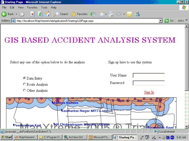
Fig 4.7 Starting page of Web GIS based
Accident Analysis System
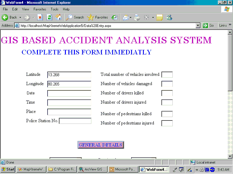
Fig 4.8 Data Entry form of web GIS based Accident Analysis System
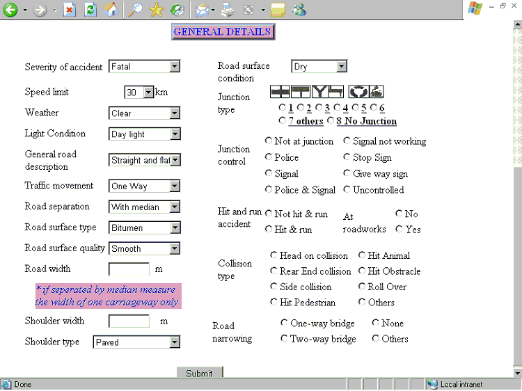
Fig 4.9 Continuation of Data Entry form of web GIS based Accident
Analysis System
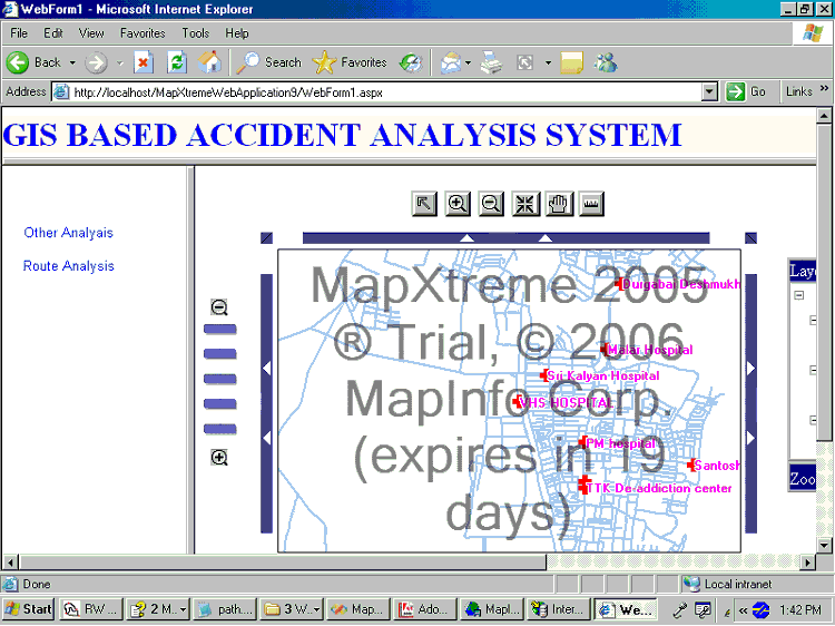
Fig 4.10 Analysis Model Page of web GIS
based Accident Analysis System
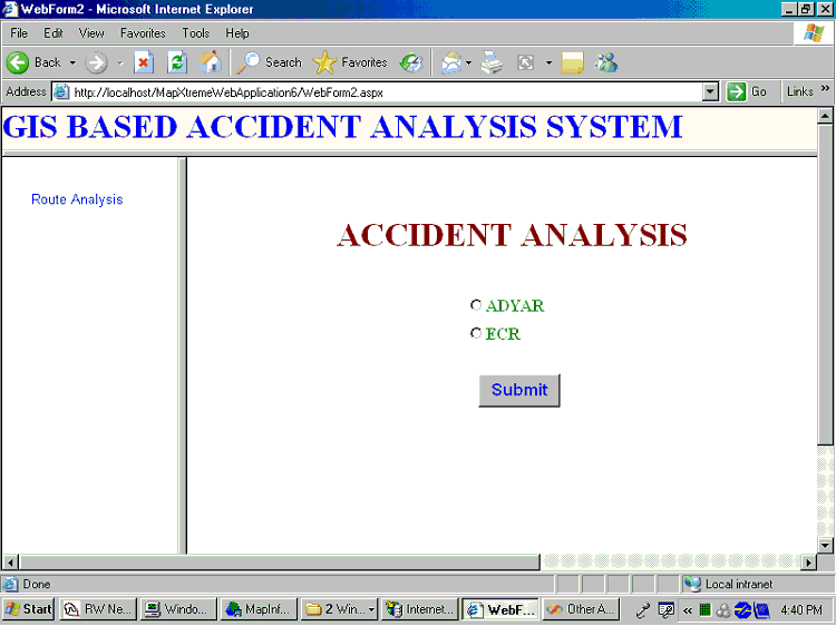
Fig 4.11 Analysis Model showing Other
Analysis
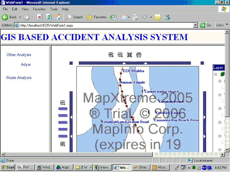
Fig 4.12 Analysis Model showing Accident
location on
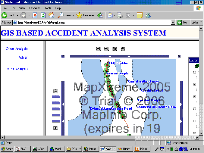
Fig 4.13 Analysis Model showing 100 m
buffer for accident location on
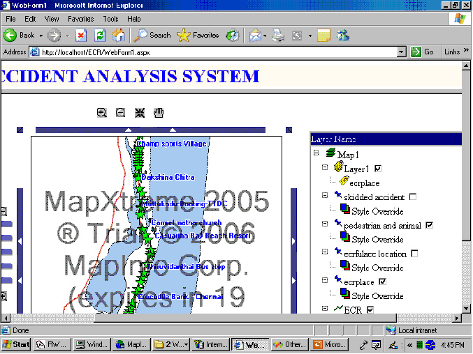
Fig 4.14 Analysis Model showing Pedestrian
accident location on
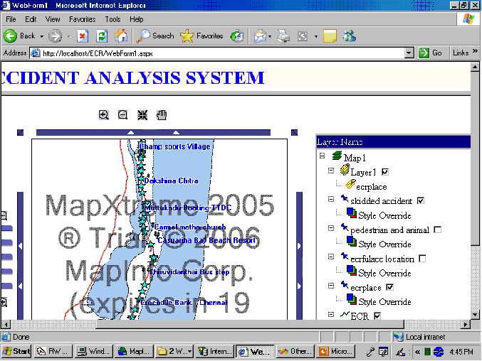
Fig 4.15 Analysis Model showing Skidded
accident location on
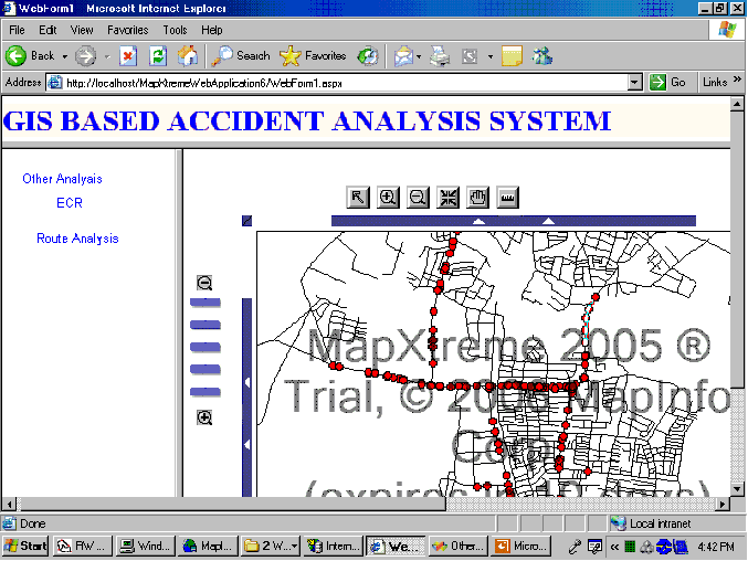
Fig 4.16 Analysis Model showing accident
location in Adyar Thaluk.
4.5.3 ROUTE
ANALYSIS
RWNetServer has the functions to work with the GIS network data. This can be combined and use with GIS map server. And allows the user to interact through web. It will calculate the network according to the user query and generate output as a GIS file. However, GIS map server required to display the result. C# programming is used to access the RWNetserver and Fig 4.17 shows the Route analysis model.
User Interface has designed in such a way to get the latitude and longitude of the accident location for locating the nearest hospital and direction to travel to that hospital. Following figure explains to perform the route analysis in the developed system.
- Enter The latitude and longitude on the TextBox shown in left side of the web page
- Click Submit Button to perform the Analysis fig 4.18.
- Shortest route for the nearest hospital will be displayed on map fig 4.19 and 4.20.
- Click the reset link which is on top of the page to do the application again.
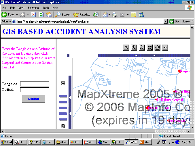
Fig 4.17 Route Analysis Model
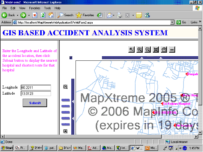
Fig 4.18 Route Analysis Model getting
accident coordinates from the user
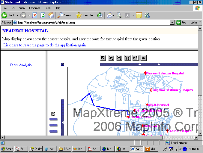
Fig 4.19 Route Analysis Model show shortest
route to the nearest hospital for given accident location
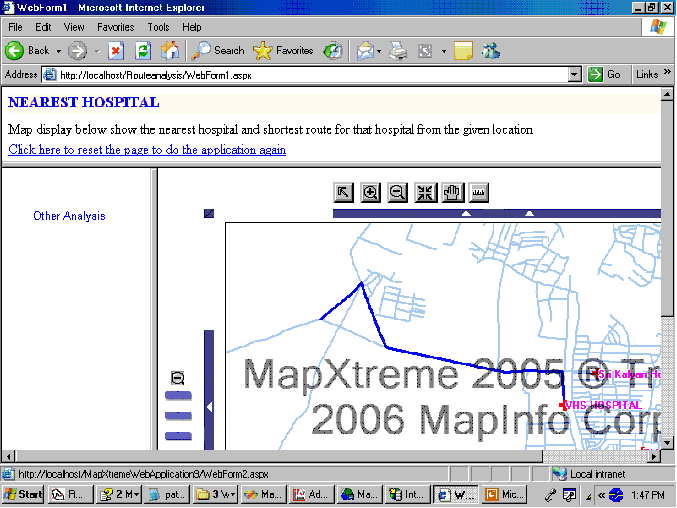
Fig 4.20 Zoom in View of shortest route to
the nearest Hospital location